
Physical & Locational Characteristics
VHEMBE DISTRICT MUNICIPALITY was established in the year 2000 in terms of Local Government Municipal Structures Act 117 of 1998. The VHEMBE DISTRICT MUNICIPALITY IS located in the Northern part of Limpopo Province and shares boarders with Capricorn and Mopani District Municipalities in the southern and eastern directions respectively. The sharing of boarders extends to Zimbabwe and Botswana in the north and west and the Kruger National Park in the east respectively. Map indicates the location in relation to the other municipalities and countries.
The District covers 21 407 square km of land with total population of 1.199 884 million people. The population mainly comprised of women (55%) with 50% of the population being under the age of 20 years. The district settlement patterns are largely rural with �576-dispersed villages. The district is still faced with infrastructural backlog: water 56% sanitation 68%, and electricity 46% below RDP level of services.
Vhembe District Municipality is located in the Northern part of Limpopo Province and shares boarders with Capricorn, Mopani District municipalities in the eastern, and western, directions respectively. The sharing of boarders extends to Zimbabwe and Botswana in the North West, and Mozambique in the east south through the Kruger National Park respectively as indicated in figure 7 below. The District covers 21 407 square km of land with total population of 1.240 035 million people according to Stats SA, 2007 of which 1.1% of the district is urban area.
The land is very fertile and good for agriculture. Large part of the land falls under the tribal authorities. This makes it difficult for development to take place, as the land tenure system is not favorable to commercial development. The population mainly comprised of 54, 4% women and 45, 5% men, with 51, 3% of the population being under the age of 20 years. The district settlement pattern is largely rural with approximately 774 dispersed villages and 287 190 number of households. Vhembe has parts of the two Trans Frontier Parks that involve four countries. The Kruger National Park of South Africa, Gonarezhou of Zimbabwe and Limpopo National Park of Mozambique form the Great Limpopo Trans frontier. Mapungubwe National Park of South Africa, Tulip Circle Safari Area in Zimbabwe, and Northern Tuli Game Reserve of Botswana are integrated to form Limpopo-Shashe Trans frontier Park. This presents Vhembe with a great potential to grow in the tourism sector. Vhembe is located in the remote areas of South Africa thus makes it difficult for the produce of Vhembe to reach the National Markets of South Africa. Nevertheless, when it comes to the SADC markets, Vhembe is strategically located as it is easy for companies to access these markets through the three border gates found in Vhembe. The fact that Vhembe shares the borders with three African States also brings its own challenges. The socio-political situations in those countries affect South Africa as a whole but the impact is more in Vhembe. Currently the Zimbabwean situation is putting a lot of stress in the Vhembe District as many Zimbabweans cross to South Africa seeking services that cannot be found in their country.
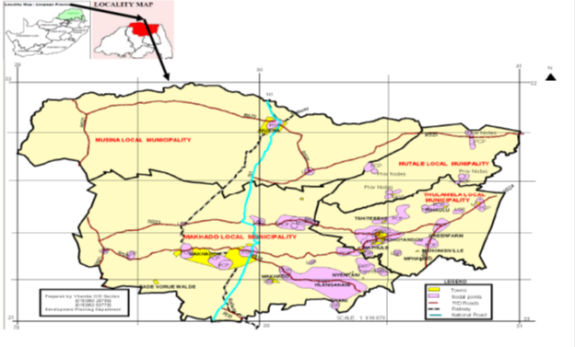
Map: geographical location and boundaries of Vhembe District Municipality in Limpopo Province.
Spatial Development Framework (SDF)
Limpopo Province has developed Provincial Spatial Rationale which has identified settlement hierarchy for the whole Province and also makes provision for settlement hierarchy for Vhembe District Municipality. The Spatial Rationale highlighted the settlement hierarchy based on the classification of individual settlements (i.e. towns and villages) in which the hierarchy is characterized as follows:
First order settlement (Growth Points) which are further characterized into three categories i.e.
- Provincial Growth Point;
- District Growth Point;
- Municipal Growth Point;
- Second Order Settlements (Population Concentration Point);
- Third Order Settlement(Local Service Points);
- Fourth Order Settlement( Villages Services Areas);
- Fifth Order Settlement ( Remaining Small Settlements);
Settlement Clusters indicate priority development areas/ nodes in which primarily first order settlement and second order settlements are identified. Growth Points are therefore the highest order in the settlement hierarchy, with population concentration points being the second order in the settlement hierarchy. The Vhembe District Municipality Spatial Development Framework comprises of the following key development priority areas.
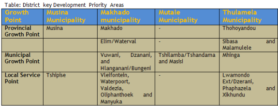
Table: District key Development Priority Areas
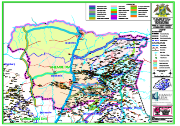
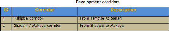
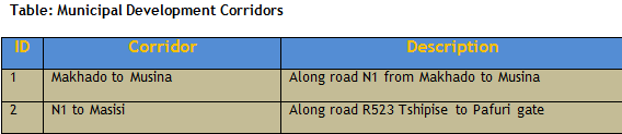
Proposed Development Corridor
- Tshipise Corridor- from Tshipise to Sanari
- Shadani/ Makuya Corridor- from Shadani to Makuya
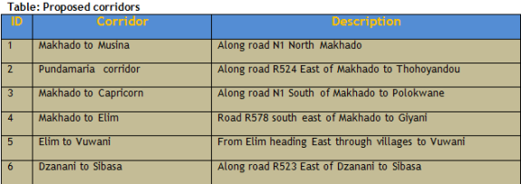
- Makhado to Messina- Along road N1 North Makhado
- Punda Maria Corridor- Along road R524 East of Makhado to Thohoyandou
- Makhado to Capricorn- Along road N1 South of Makhado to Polokwane
- Makhado to Elim- Road R578 south east of Makhado to Giyani
- Elim to Vuwani- From Elim heading East through villages to Vuwani
- Dzanani to Sibasa- Along road R52 east of Dzanani to Sibasa
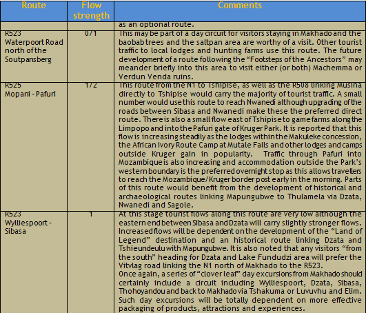
Tourism Sector within the District
These are areas within the district which forms part of the four Local Municipalities in which provision of infrastructure should also be prioritized to these areas to attract tourist. Amongst these areas includes: Dongolo Trans-National Park, Soutpansberg Conservation, Nwanedi Nature reserve, Baobab Nature Reserve, Kruger National Park, Langjan Nature reserve, Happy Rest Nature Reserve and Honnet Nature Reserve.(refer to the map) Moreover, Municipal boundaries have created artificial barriers that cut across geographical areas, which should normally be regarded as tourism destinations. Amongst those Tourist destination areas includes the following areas:
The "Venda Heartland". This will be proposed as an important destination and attractions or products such as Dzata, Lake Fundudzi, Thate Vondo Forest and Phiphidi Waterfall, for example, actually lie within the three separate Local Municipalities of Makhado, Thulamela and Mutale. If Tshipise is regarded as a component of this destination then Musina Local Municipality would also be involved.
There is also Rock Art, Archaeological and Historical Routes that falls within four Local Municipalities within Vhembe would need to be involved as well as Blouberg Municipality where the Mankweng is a critical part of the rock art attractions and Kruger National Park as the custodian of the Thulamela Archaeological site.
The proposed new Gate into Kruger Park at Shangoni would physically be in the Thulamela Local Municipality and yet the main access road would be via Giyani that falls under Greater Giyani Local Municipality.
Middle Letaba Dam is also a "border-line" case with the northwest (left) bank being in Makhado Local Municipality and the south-east falling within Greater Giyani. Future planning of any waterside resorts or facilities would need to ensure adequate consultation and joint planning.
Significant Agricultural Occurrence
Vhembe District Municipality generates an intermediate contribution towards the provincial agriculture sector (11.1% in 1980 and 18.6% in 1994). The most important agricultural commodities are nuts (about 50% of provincial production), and subtropical fruit (26% of provincial production). The most important production area for these commodities is the Levubu Valley (Refer to the SDF map).
The north and western parts of the district is sparsely populated, whereas Thohoyandou is one of the most densely populated areas in the Province. The nodes are well defined, with Makhado, Thohoyandou and Musina as the most important.
The area north of the Soutpansberg mountain range is Mopani veld, and is only suitable for extensive cattle or game farming. There are a number of irrigation regions along the more important river systems with the Limpopo, Nwanedi and Nzhelele regions as examples. The Limpopo Valley in particular is well suited for the production of Dates, for which there is a proven market. The Soutpansberg mountain range is an important forestation area and 15 563 ha are planted with soft and hard woods. This area (Dry and Wet Soutpansberg) is also suitable for the production of crops such as Avocado, Macadamia, Citrus and Flowers. The Thohoyandou district (which falls largely in the Levubu irrigation area) has high agricultural potential and is suitable for the production of crops such as Avocado, Macadamia, Mango, Citrus and Paprika. However, the production potential of this area is negatively impacted by high population concentrations which sterilize high potential agricultural land and place much pressure on the water resources. The same also applies to the Dzanani and Vuwani districts where the average population density varies from 100 to 200 persons per km2. The urban space in these areas reflects a large number of informal villages of varying sizes that were originally established and have since grown organically with very little planning.
Only about 4, 72% of the total land area can be considered arable. Of this potential, 72% is used for dry land production and 20% is under irrigation. About 78% of the land area is suitable for grazing. A sizeable portion (16%) is used for the purposes of nature conservation or forestry.
Significant Mineral Occurrences
Minerals can be considered a finite resource. In addition, mineral deposits are also fixed in space (i.e. their geographic location). As such, mineral deposits influence and determine the macro spatial patterns in terms of the location of mining activities and mineral processing activities. It is therefore important to locate and describe those mineral occurrences that can be considered significant in terms of the type of mineral, the degree of the deposit, the current and possible future demand and price levels. Within the context of the Spatial Rationale, these significant mineral deposits can be considered mineral / mining zones that impact and determine land uses. Some of these zones have been or are being exploited at present. In cases where no exploitation has taken place as yet, it is important to highlight the location of these particular zones in order to prevent or minimize their sterilization with other land-uses (e.g. urban development). Mining activities indicated in map 6.
The most important mineral occurrences and zones in the Vhembe District include:
- Beit Bridge Complex / Limpopo Belt;
- The Tuli, Mopane, Tshipise and Pafuri coal fields;
- Tshipise magnesite field;
- Musina copper;
- Schiel Complex; and
- Soutpansberg group
(a)Beit Bridge Complex / Limpopo Belt
The complex hosts a number of minerals, the most important of which include:
- Iron: Exploration drilling by ISCOR on the farms Moonlight (111LR), Julietta (112 JR) and Goudafontein (76 LR) south of Marnitz indicated occurrences of magnetite. Reserves are estimated at 470 Mt.
- Dolomite:The Gumbu Group has significant reserves. However, the long distances to markets marginalize the economy of these reserves. Deposits that have been exploited include that on the farm Steenbok (565 MT) and Nous (178 MT).
- Diamonds: The Limpopo River is known to have significant alluvial diamonds. However, no deposits are mined at present and the only deposit mined in the past is located on the farm Riedel (48 MS). Prospecting has indicated diamonds to occur on the farms Krone (104 MS), Blyklip (25 MS), Halcyon (21 MS), Little Bess (70 MS), Skutwater (115 MS), Bismark (116 MS), and River (141 MS). The only active diamond mine at present is the Venetia Mine.
- Marble: Known occurrences of marble are on the farms Kairo (212 MR) and Baklykraal (265 MR), northwest of Alldays.
- Graphite:Two mines used to exploit graphite namely the Gumbu and the Mutale Graphite Mine (both have been closed). A known reserve of flake graphite occurs at Dreamboat.
(b)Tuli, Mopane, Tshipise and Pafuri coal fields.
The economics of these fields are marginalised by the long distances to markets. At present, only the Pafuri coal field is exploited by the Tshikondeni Mine, which produces coking coal for ISCOR's Vanderbijlpark plant.
(c)Tshipise magnisite field
The field stretches from Tshipise for about 50km in a east-northeast direction. A number of occurrences are located in this field such as that on the farms Graandrik (162 MT), David (160 MT), Frampton (72 MT), etc. The field is exploited by only one operation namely the GeoCarpo Mine.
(d)Musina copper
Copper occurs in the Messina fault. This deposit was exploited by the Messina Development Company, which was terminated in 1991.
(e)Schiel Complex
The Schiel complex is the largest alkaline plutonic occurrence in the Limpopo Province (133km2), and it is located halfway between Makhado and Giyani. A phosphate deposit covering an area of about 2km2 occurs on the farm Schiel (54 LT). The reserve has been prospected by Foskor and is estimated at about 36Mt.
(f)Soutpansberg group
A number of minerals are associated with the Soutpansberg Group including corundum, feldspar, garnet, graphite, kieselguhr, limestone, phosphates and talc.
Settlement and spatial patterns
The spatial pattern can be described as the physical manifestation of various form-giving processes and forces, or which economic and political processes and forces are the most dominant in the establishment of a spatial pattern. Although the spatial pattern is permanent in its nature, it changes constantly over time, mainly due to the nature and extent, as well dynamics of these processes and forces. These changes can take various forms. The existing spatial pattern is a result of these processes and forces, and in turn generates the potential for and/or restricts the functioning and development of these processes and forces.
The basic elements of a spatial pattern is comprised of nodes, networks and areas which in their turn are made up of macro land-uses such as settlements (e.g. residential, industrial and business land-uses) agricultural areas, mining areas (activities), conservation areas and communication/transport networks.
The purpose of the Limpopo spatial rationale is, therefore, to identify an optimal spatial pattern, which by implication means that the land needed for the various macro land-uses, such as settlements (e.g. residential areas, industrial and business zones), agricultural development, mining activities, nature conservation areas, etc. should be preserved for existing, as well as future development in order to prevent or minimize sterilization of these areas/land-uses.
Most of these macro land-uses such as mineral deposits and high potential agricultural land are much localized and is, therefore, subject to sterilization if it is not zoned timeously for these specific purposes.
The spatial rationale (inclusive of a macro spatial plan) for the Limpopo Province was finalized in 1999. The purpose of this project is, therefore, only to review and update the original spatial rationale in view of the many changes that have taken place since the compilation of the spatial rationale.
A settlement hierarchy has, therefore, been identified which includes all types of settlements including both proclaimed towns and rural villages. The settlement hierarchy (macro spatial plan) for the Limpopo Province has become a fairly well established concept with departments in the province. Most departments acknowledge the proposed hierarchy of settlements and consider it in decision making when involving the spending of public funds (e.g. housing projects, provision of bulk infrastructure, etc.). The settlement hierarchy will, however, be reviewed and updated as a result of recent changes such as new legislation, re-demarcation of municipalities, etc. Furthermore, the potential impact of land reform has to be understood and considered in terms of its influence on land-use patterns and the spatial development framework.
Hierarchy of Settlements and Settlement Densities
Approach followed with the Identification of a Settlement's HierarchySettlement hierarchy is usually identified based on the classification of individual settlements (i.e. towns and villages). This would mean that the approximately 2400 towns and villages in Limpopo would have been individually classified in terms of a proposed hierarchy. Polokwane would have been the highest order settlement with second order settlements such as Mokopane, Thohoyandou, Tzaneen, Makhado, etc. Third order settlements would have included places such as Jane Furse, Giyani, Lebowakgomo, etc.
Fourth order settlements would have included larger isolated settlements such as Elandsfontein, Van der Merweskraal, Bakenberg, Moganyaka, etc. with the fifth and last order settlements being all the villages which are relatively small, and dispersed throughout the various districts, with no economic base at all.
This kind of approach would have resulted in a very detailed classification categorizing the individual towns and villages in terms of the relevant order in a five-tier hierarchy. The approach would have resulted in a very scattered settlement hierarchy. Although a number of criteria are used for the classification of settlements in terms of a hierarchy, it is also appropriate to choose a classification for a hierarchy which is suitable for the level of planning and the specific circumstances. The levels of planning vary from a macro level (e.g. national or provincial levels) to a more detail level being smaller districts, regions or individual municipal areas.
A total of approximately 2400 settlements (e.g. towns and villages) exist in the Limpopo Province, and are scattered throughout large parts of the province, although villages are primarily isolated to the former homeland areas.
The existing settlement pattern in the province, however, reflects a distinctive pattern where some of the settlements are grouped or located relatively close to each other, with a substantial number of people residing in these settlement groups. It was therefore decided that for the purposes of the spatial rationale (which is a macro spatial planning exercise) to opt for the identification of clusters (e.g. nodes where a group of settlements are located relatively close to each other). These clusters were identified based on criteria of the 1999 Spatial Rationale Study (Scenario Formulation). The highest order settlements in the settlement hierarchy are, therefore, mainly settlement groups (clusters) although individual settlements, especially with the existence of larger towns, are also included in the first and second order settlements. The clusters were further divided into two separate categories, viz. growth points (first order settlements) and population concentrations (second order settlements), both being part of the cluster concept. Growth points are the highest order in the settlement hierarchy, with population concentrations being the second order in the proposed settlement hierarchy.
Description of Various Settlement Types
The first and second order settlements in the proposed hierarchy are described and explained as follows:
Growth points are towns/villages or a group of villages located relatively close to each other where some form of economic, social and institutional activities, and a substantial number of people are usually found.
These growth points seem to have a natural growth potential, but do not develop to their full potential due to the fact that capital investments are made on an ad hoc basis without any long term strategy for the area as a whole.
The identified growth points should be stimulated by amongst others, providing a higher level of service infrastructure which will ensure that appropriate services are available for potential business and service/light industrial concerns. The higher level of services, relative to other settlements in the area will also attract residential development to these growth points, with the implication that certain threshold values in population be reached, to provide for higher levels of social, physical, institutional and economic services.
Population concentration points are towns/villages or a group of villages located close to each other, which have virtually no economic base, but a substantial number of people located at these villages. These population concentrations are mainly located adjacent to tarred roads or intersections of main district routes, which provide accessibility to job opportunities. These nodes should also be given priority in terms of infrastructure provision with a higher level of services, although not at the same level as for growth points. This approach should be followed to attract people from other smaller villages with a lower level or no service infrastructure.
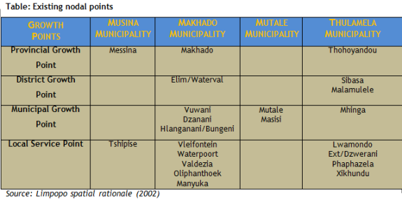
Comparison of Population Features between Local Municipalities in the Vhembe District Municipality Area
A summary of the estimated 2001 population, number of settlements, household size and average number of people per settlement per local municipality in the VHEMBE DISTRICT MUNICIPAL area. It is evident from the census 2001 that Musina has the smallest number of settlements (7) and also the smallest population, viz. 40836 people. Although the average number of people in the 7 settlements in the Musina Local Municipal area is 5834 people in 2001, it is misleading as the majority of the people residing in settlements are living in Musina/Musina-Nancefield.
Thulamela is by far the largest local municipality with 579575 people and is followed by Makhado Local Municipality with 496198 people. Mutale on the other hand is also relatively small, although bigger than Musina with 75643 people. The total population for the 4 local municipalities in Vhembe District Municipality amounts to 1 192 252 for 2001.
The largest settlements are located within the Thulamela and Makhado Local Municipalities. Large settlements in Makhado Local Municipality includes Chavani (10672 people), Makhado (11368 people), Magoro (14049 people), Olifantshoek (8692 people), Tshakhuma (16047 people) and Waterval Urban (9562 people). The following settlements in the Thulamela Local Municipality are fairly large, viz: Makwarela (17014 people), Malamulele (8655 people), Mukula (8914 people), Maungani (8008 people), Muledane (11558 people), Shayandima - 2 extensions (32887 people), Tshikonelo (8659 people) and Tshisahulu (8934 people).
Thulamela Local Municipality with 27 large settlements and Makhado Local Municipality with 23 large settlements have 96% of all the large settlements with 5000 people and more in the VHEMBE DISTRICT MUNICIPALITY.
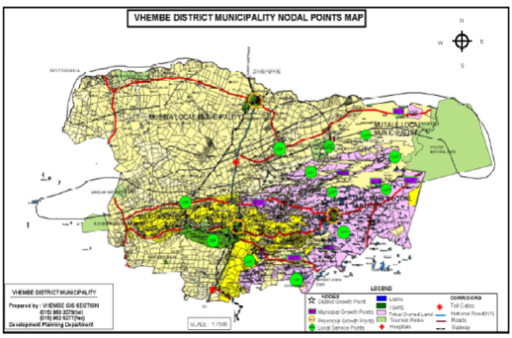
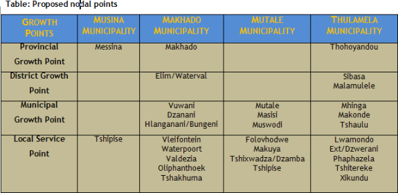
District Wide-existing Nodal Points
In terms of the Limpopo Spatial Rationale the above nodal points identified in table 4 are the existing nodal points.
The municipality has two municipal growth points, which are Masisi and Mutale. The municipality has 2 population concentration points, which are Folovhodwe and Mulodi. It is also composed of villages and few farms. The municipality is linked to other areas with road networks. The municipality does have a population of approximately 131781 people. The proposed growth points of the municipality are:
- Tshandama/Tshilamba municipal growth point
- Masisi municipal growth point
- Makuya local service point
- Muswodi growth point
- Tshixwadza local service point
- Folovhodwe local service point
The municipality has a provincial growth point which is Thohoyandou and two district growth points which are Sibasa and Malamulele and one municipal growth point which is Mhinga; we also proposed two municipal growth points which are Makonde and Tshaulu. List of growth points within the municipality
Provincial growth point
- Thohoyandou
District growth point
- Sibasa
- Malamulele
Municipal growth point
- Mhinga
- Makonde
- Tshaulu
Local service point
- Lwamondo extension/Dzwerani
- Phaphazela
- Tshitereke
- Xikundu
Growth points
a)Proposed Major Growth Points
MakhadoThe town of Makhado is situated along the N1 North at approximately �110 km from the Beit Bridge border of South Africa and Zimbabwe. The Makhado Town has a trade relationship with the cities in Zimbabwe
VuwaniVuwani is situated in the eastern side of Makhado town, it's one of the Makhado Municipal growth point; Vuwani town is composed of different activities like police station; community halls; commercial activities, Magistrate offices etc.
Elim / WatervaalElim is one of Makhado municipal growth point; it is situated in the southern side of Makhado town; Elim town composed of different activities such as hospital, agricultural, commercial etc.
DzananiDzanani is one of Makhado municipal growth point; it is situated in the northern side of Makhado town; Makhado town composed of different activities such as hospital, agricultural, commercial; Police station; Magistrate offices etc.
b) Proposed Minor Growth Points
Madombidzha/Kutama and SinthumuleThe Madombidzha area situated in the western side of Makhado town; it is approximately �30KM from Makhado Town; Madombidzha is one of the local service points for Makhado town.
Hlanganani / Bungeni
It is situated in the south east of Makhado town; the area is composed of different activities such as community halls; commercial activities etc.
Proposed Local service point
- Tshakhuma
- Waterpoort
- Chavhani
- Vleifontein
- Oliphanthoek
Vhembe District Municipal Proposed Growth Points
The Vhembe district growth points, municipal growth points and local service points are indicated in diagram below.
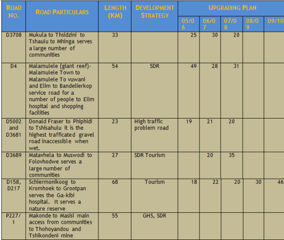
The major problems identified in this section are that Traditional leaders demand royalties for borrow pit, shortage of borrow material, shortage of resources, lack of Road management system, insufficient budget and shortage of staff and collapsing bridges. The National road (N1) covers 150 km of surfaced road while Provincial roads covers 762.2km of surfaced and 1145.47km of gravel roads in the district. The district surfaced roads cover 153.48 km and gravel 2021km.
Storm-water infrastructure
Lack of as built drawings, unknown bridges life span, non-implementation of maintenance plans, lack of previous maintenance history or records and delays in reconstruction of collapsed Lutanandwa River Bridge are the main challenges. The bridges No. 1718 which and 1721 have cracks on the bridge decks which is the sign that shows that those bridges are about to collapse.
Provincial bridges in Punda Maria road (P98/1) bridge no. 1288 was constructed in 1954 at Lutanandwa river, and bridge no. 1718 and 1721 (Piesanghoek) were both constructed in 1962. There are 49 district bridges. D2474 Luvuvhu Road Bridge no 3472 was constructed in 1983.
Routine maintenance
Regular break down of machines and equipment's, shortage of machines and ageing personnel are the major challenges in the district.
Cost centersThere is only 02 cost centers in Makhado municipality: Makhado which manages 338 km of surfaced and 488 km unsurfaced roads using 03 Graders, 01 Bomac, 01 trailer and 05 flat trucks while Hlanganani maintains 133 km surfaced and 423 km unsurfaced roads.
The plant lists at Hlanganani are 03 graders, 01 Bomac, 01 trailer, 03 flat trucks and tar cutter. Thulamela municipality has Thohoyandou and Malamulele cost centers. Thohoyandou cost center cater for 240 km surfaced and 355 km unsurfaced roads with 04 Graders, 02 Bomac, 03 flat trucks and 02 trailers. Malamulele caters for 115 km surfaced and 355 km unsurfaced roads using 03 Graders, 01 Bomac, 04 flat trucks, and 02 Trailers, 01 Tar cutter and 01 Homelite. Mutale municipality has only Tshilamba which maintains 140 km of surfaced and 415 unsurfaced roads with 02 Graders, 01 Bomac, 03 flat trucks and 01 Smashers for bush clearing. Musina municipality has 01 cost center with a plant list consisting of 03 graders, 01 Bomac and 04 flat trucks to maintain 415 km surfaced and 667 km unsurfaced roads.
The district is faced with high backlog in road and storm water management. Poor roads and storm water infrastructure is impacting negatively in the economic growth in the district especially access to tourism attraction spots. Due to lack of capacity particularly available machinery, municipalities are unable to service their economic potential identified areas. The huge service backlog makes it difficult for municipalities to cope with the demand. However, the revised powers and functions put the responsibilities to local municipalities which leave the District playing a minimal role of coordination. Roads and storm water infrastructure remains the District priority because of the magnitude of backlog even though projects to address access roads and storm water infrastructure will be done by local municipalities and sector departments "inter alia" Transport and Public Transport and Road Agency Limpopo (RAL).
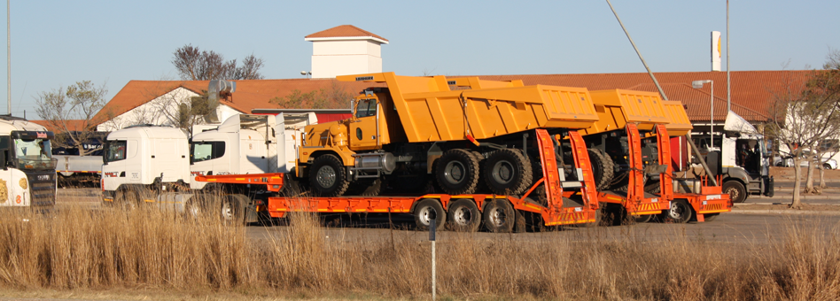
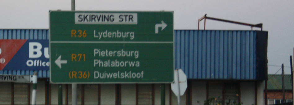
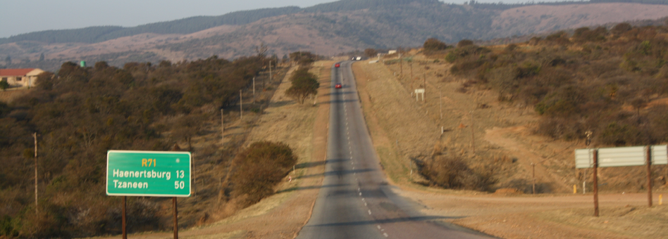
Road And Transport Network
Road and transport network is indicated in map attached.
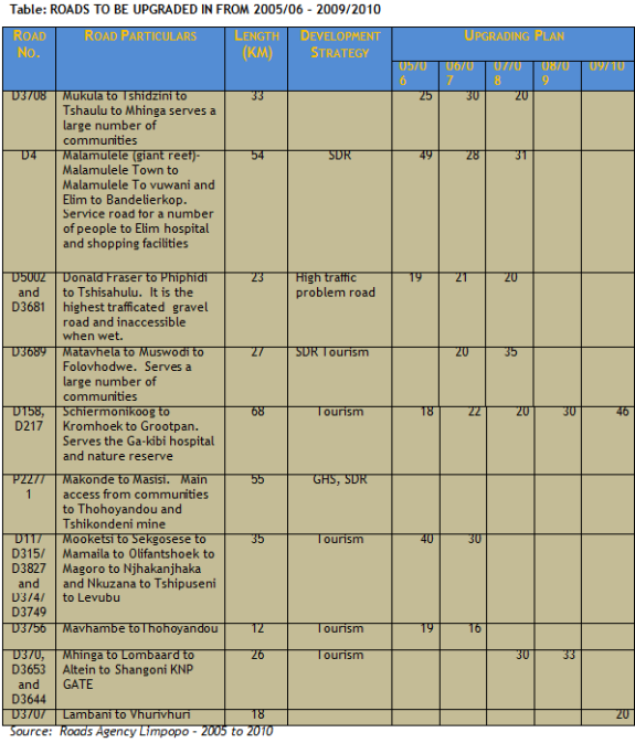
Source: Roads Agency Limpopo - 2005 to 2010
Roads and stormwater infrastructure development
- Roads National N/A
- Provincial To facilitates the upgrading of Provincial Roads and Storm Water Infrastructure at all times
- District to improve 20km of roads accessibility.
- Municipal To ensure that 40km of municipal streets are tarred by 2010/11
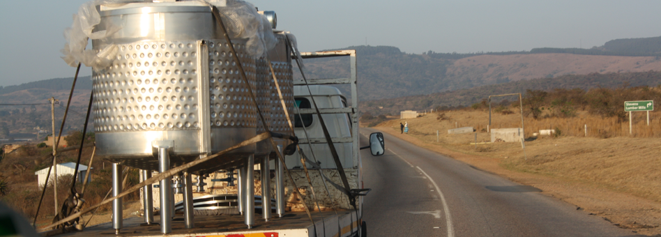
These roads are surfaced (tarred) and continuously maintained. The other areas are serviced by re-graveled roads, gravel roads, low volume surfacing and rural roads. Most of the gravel roads are not maintained regularly. In addition to that, some of the roads in the district do not have route names and numbers. They also do not have appropriate road signs (e.g. speed limits) as well as signs indicating distances between destinations. Another problematic issue on the district roads is that, in most areas, fencing along the routes has been removed. This has resulted in wild and domestic animals wandering on the roads with detrimental effect to motorists, and thus, negating our tourism attraction efforts as a region. Many road accidents in the district can be attributed to animals roaming on the roads. It is interesting to note new roads fencing projects in the district.
Main Menu

Other Links
Copyright © 2012 Limpopo Province Freight Transport Data Bank | Developed and Powered by Safiri South Africa.