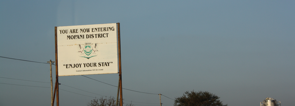
The Mopani District municipality is situated in the North-eastern part of the Limpopo Province, 70 km and 50km from Polokwane (main City of the Limpopo Province), along provincial roads R81 and R171 respectively. It is bordered in the east by Mozambique, in the north, by Zimbabwe and Vhembe District Municipality, in the south, by Mpumalanga province through Ehlanzeni District Municipality and, to the west, by Capricorn District Municipality and, in the south-west, by Sekhukhune District Municipality. The district has been named Mopani because of abundance of nutritional Mopani worm found in the area. The district spans a total area of 2 534 413 ha (25 344,13 km�), inclusive of Kruger National Park which occupies 43% There are 14 urban areas (towns and townships), 352 villages (rural settlements) and a total of 118 wards. The Mopani District, by virtue of the Kruger National Park as part of the District Management Area, is also part of the Great Limpopo Transfrontier Park, the park that combines South Africa, Mozambique and Zimbabwe.
The strategic location of the District embodies both advantages and disadvantages. The communities of Mopani should be well positioned, in order to harness advantages that come with neighbourliness of the two countries. The converse is also true.
Map: Mopani District Municipality
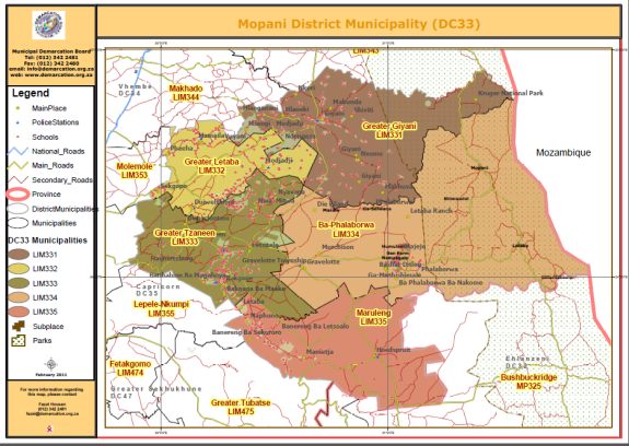
Source: Municipal Demarcation Board
Greater Tzaneen
The Greater Tzaneen Municipality is situated in the eastern quadrant of the Limpopo Province within the district's area of Jurisdiction, together with Greater Giyani, Ba-Phalaborwa, Maruleng and Greater Letaba. Polokwane to the west, Greater Letaba to the north, Ba-Phalaborwa and Maruleng to the east, and Lepelle-Nkumpi to the south, border the Greater Tzaneen Municipality and Giyani border.The Greater Tzaneen Municipality comprises a land area of approximately 3240 km�, and extends from Haenertsburg in the west, to Rubbervale in the east (85km), and just south of Modjadjiskloof in the north, to Trichardtsdal in the south (47km). The municipal boundaries form an irregular, inverted T-Shape, which results in certain developmental implications for the municipality, and more specifically the distance to markets, difficulties in respect of service provision, and constraints to implementing the development strategy of the municipality.
The Greater Tzaneen Municipality area encompasses the proclaimed towns of Tzaneen, Nkowankowa, Lenyenye, Letsitele and Haenertsburg. In addition, there are 125 rural villages, concentrated mainly in the south-east, and north-west, of the study area. Almost 80% of households reside in these rural villages. The municipal area is further characterized by extensive and intensive farming activities (commercial timber, cash crops, tropical and citrus fruit production); mountainous, inaccessible terrain in the west and south, and un-even topography (gentle slopes) to the north and east; areas with exceptional natural beauty, with considerable untapped tourism potential.
Greater Letaba
The Greater Letaba Municipality area is the smallest local municipality in the district in terms of land area and is situated in the west of the Mopani District. The Municipality incorporates the proclaimed towns of Modjadjiskloof, Ga-Kgapane and Senwamokgope, which are situated in the South. The Municipality is furthermore characterized by contrasts such as varied topography, population densities and vegetation. The population in the municipality is denser in the north-east than in the south, whereas, vegetation is denser in the south (timber) than in the north (bushveld).
Resources are relatively scarce throughout the municipality. The municipality is, however, situated in close proximity of other natural resources at its border with Greater Tzaneen. The Tzaneen and Heanertsburg areas attract tourists due to their natural beauty, dams, waterfalls and nature reserves. The Municipality can capitalize on these resources as well as the more intensive economic activities in Tzaneen. The incidence of rural settlements is evenly spaced along the northern boundary, and a lesser concentration of villages along the south - eastern boundary, of the municipality. The south part of the municipal area comprises mountainous terrain, which precludes urban development. Approximately 5% of the land area is covered by residential development, whilst 30% of the land area of the Letaba Municipal area is taken up by agricultural activity. These include tomatoes (central), Timber (south and south east), game and cattle (central and north west).
Greater Giyani
Greater Giyani Municipality is located in the North of the Mopani District Municipality with Giyani as its only town. Giyani is also the home of the District Municipal offices and previously housed the administrative offices of Gazankulu homeland. Giyani town is the largest centre of population concentration, employment opportunities, shopping and recreational facilities in the local municipality. The economic activity that mostly takes place in Greater Giyani both formal/informal are: small-scale agriculture (maize, vegetables, tomatoes, beef), services, transport and retail development. There are however, number of factors impacting on the economic growth such as geographical location (distance to markets), shortage of skills, poor infrastructure, climatic conditions and diseases. The municipality has potential for tourism and conservation development due to the existing natural heritage sites through the area, mining, latent farming schemes, processing of natural products (Mopani worm and Marula fruit).
Ba- Phalaborwa
The town of Phalaborwa and the nearby Namakgale/ Lulekani towns and surrounding villages constitute the major population concentration area in Ba- Phalaborwa. Another smaller rural concentration is Seloane/Nondweni with the tourist resort of Eiland nearby. The area has a unique natural environment comprising conservation areas and eco- tourism development together with the bordering Kruger National Park. This and the large mining development form a key economic driver. Although mining is presently the largest sector in Ba-Phalaborwa and created many job opportunities it can also become a constraint in the future. All mines have certain production expectancy and will eventually close. There is a large amount of land in Ba-Phalaborwa that is currently under land claims. This is land that can potentially be developed for especially tourism.
Maruleng
The Maruleng Municipality is situated in the south-eastern quadrant of the Limpopo Province within the Mopani District. The municipal area extends over 324 699ha and is bordering Kruger National Park to the east, The Ba-Phalaborwa and Greater Tzaneen to the North, the Lepelle Nkumpi Municipality to the west, and the Tubatse Municipality and Bushbuckridge Municipalities to the south. The municipal area is characterised by typical Lowveld vegetation and is evenly sloped with isolated kopies and ridges. To the south, the municipal area also borders the Drakensberg escarpment. Population densities vary from sparse in the east, to relatively dense in the South - West. A definite fragmented urban and rural form is evident in all areas throughout the district. This can mainly be attributed to economic factors and racial segregation induced by past legislation causing artificial fragmentation in the rural and urban areas. The implementation of the Group Areas Act resulted in the segregated residential development pattern that saw the Black, Asian and Coloured population groups being removed to peripheral and separate locations. Within Mopani, black people have since been concentrated in the former homeland areas of Lebowa and Gazankulu. The fragmented spatial structure where most of the economic activities are concentrated in predominantly white urban concentrations and farms resulted in the concentrations of the majority of the population within areas severed by distance from their place of work. These areas experience severe poverty and low human development potential due to high illiteracy rates, low income and a general low life expectancy, accompanied by low levels of social and engineering services.
Spatial Settlement Configuration
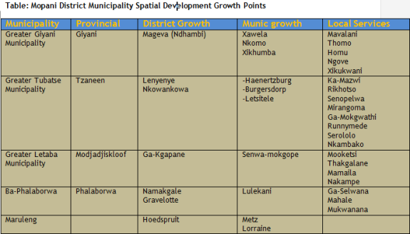
The Spatial Rationale indicates the following tendencies with respect to the settlement hierarchy in individual local municipalities:
- Approximately 63% of the total population of Ba-Phalaborwa Local Municipality are situated within first order settlements (growth points);
- Ba-Phalaborwa Local Municiapltiy has 81% of its total population residing in growth points and population concentration points;
- Greater Tzaneen Local Municipality has 59% of its total population residing in growth points and population concentration points;
- Greater Letaba Local Municipality has 59% of its total population residing in growth points and population concentration points;
- Greater Giyani Local municipality has 29% of its total population residing in growth points and population concentration points;
- Another 9% of the total population in the District Municipality are situated in 22 settlements which are classified as local service points;
- Only approximately 30% of the total population in the district municipal area (of which the majority are in the Greater Giyani Local Municipality area) is located in 4th and 5th order settlements (being village service areas and small settlements).
It is evident from the above that focus should be placed on concentrating economic development within these 16 Growth Points to increase urbanization in the District. The current dispersed settlements pattern constrains sustainable development in the area. These villages should be linked and economically dependent on each other to create a larger area for economic development. Furthermore, the Phalaborwa Spatial Development Initiative (SDI) is located within the District. The SDI is focused along the main road link from Phalaborwa to Nelspruit in the Mpumalanga Province, where the SDI joins the Maputo Development Corridor. The aim of the corridor was to create better access between the port of Maputo and the mining potential around Phalaborwa. However, all the local municipalities in Mopani District indicated that currently no projects or development initiatives have been implemented within this SDI. The Development Bank of South Africa initially identified potential projects and initiatives in the SDI based on the mining, agriculture and tourism sectors. These initiatives have, however, not been implemented. The district municipality is in the process of developing a Land Use Management System and all the locals are expected to do same.
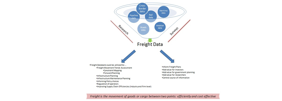
The Map below presents graphically the major transport and freight corridors in the Mopani District Municipality. The spatial analysis exercise provides a visual picture of the existing spatial pattern (that is nodes, networks and areas) that has emerged in the municipal area. This analysis serves to describe the municipal area in spatial terms and understand how space is utilized in the district. It looks at settlement patterns and growth points (nodes), population concentration areas, land claims and their socio-economic implications. All these aspects have a bearing on future land usage, infrastructure investment, establishment of sustainable human settlements, public transport and local economic development.
Map: Major Transport Route and Freight Corridors in Mopani District Municipality
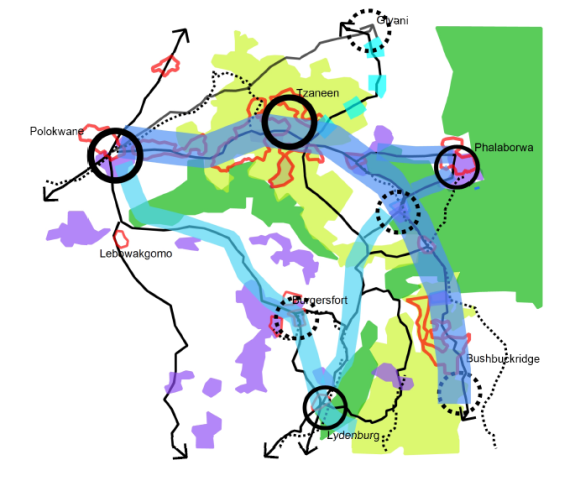
Source: Mopani Spatial Development Framework, 2011.
The Mopani District Municipality is situated within a number of strategic corridors in the Province which have a potential to offer opportunities for development in the district. The main corridors affecting the district municipality include:
Ba-Phalaborwa spatial development initiative (SDI)Traversing through the Southern side of the Municipality, this corridor is particularly well endowed with mining deposits with a number of mining operations already underway. The corridor also offers opportunities in eco-tourism and game farming due to its proximity to the Kruger National Park. The corridor is anchored on the South-East of the district by Phalaborwa and on the South-West by Tzaneen.
Tzaneen - Letaba agricultural hubThis is the hub of the extensive activities within the District Municipality where most of the citrus fruit, sub-tropical fruit and vegetables in the district are produced. This immediately offers opportunities for beneficiation (or processing of secondary products) from fruit produce. Eco-tourism is also significant in this sub- region.
Giyani sub-regionThe sub-region is also potentially rich in good agricultural soils and mining deposits. While the agricultural sector is still largely based on subsistence farming practices, the mining deposits are beginning to be exploited with huge potential spin-offs such as job opportunities and infrastructure development. The Eastern part of Greater Giyani offers tourism opportunities in game farming given its proximity to the Kruger National Park.
"The Mopani District will pursue a spatial development pattern which optimizes the benefits offered by the natural environment in terms of agricultural, tourism and mining activities. This spatial development pattern will be structured around a network of key development nodes and corridors corresponding with the provincial spatial rationale and national spatial development perspectives.
Numerous opportunities exist for economic development in the District. These opportunities were identified through gaps in the business sector and overall needs of the surrounding population that are currently not met. Support to SMMEs is highlighted with regards to training, access to markets, access to funding and access to information. Support should also be given to small-scale farmers who are currently struggling with access to funding, implements (inputs), a market for their produce and a lack of agricultural skills and administration. Forward and backward linkages also present opportunities for development. Agricultural inputs and outputs create opportunities in the manufacturing and processing sector. Furthermore the availability of raw materials and resources creates the opportunity for small-scale mining (minerals), tourism (water sources and natural beauty) and processing (Agricultural products). The District should also tap into the global market and needs to ensure that they harness the available external opportunities.
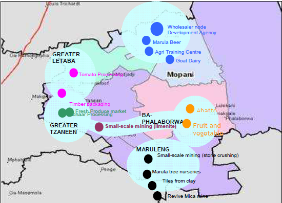
In light of the key sectors identified in the District and the existing opportunities identified the LED strategy developed seven strategic thrusts for economic development. These thrusts had been identified during the process of consultations with various roleplayers including government departments, the community, businesses and workshops. These thrusts and programmes are furthermore supported by projects. The projects that have been identified in the LED are aimed at economic development in the District. A number of these projects need to be facilitated by the District and local municipalities before it can be implemented. Furthermore the implementation of the projects that had been identified will ensure that more job opportunities are created, skills development takes place and that opportunities are created for SMME development. The aim of these projects is also to address poverty relief and to increase community ownership. Priority projects were identified based on job creation, skills development, community involvement, SMME development and overall economic impact on District level. Below is indicated the Thrusts along with the Programmes identified. The following Map indicates the priority projects and their preferred locations. A number of these projects should be located in urban areas such as the Wholesaler node and the Development Agency while other projects such as the Tomato Processing and Marula Beer brewery can be located in more rural areas. The projects that will be situated in the more rural areas will give the community much needed economic growth, and skills development. It is however evident that the priority projects for the District are well dispersed throughout the whole District.
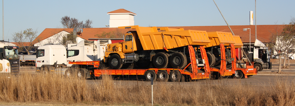
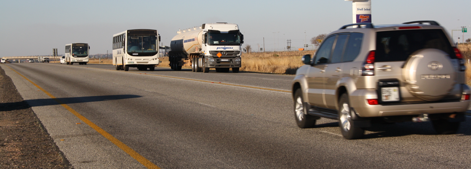
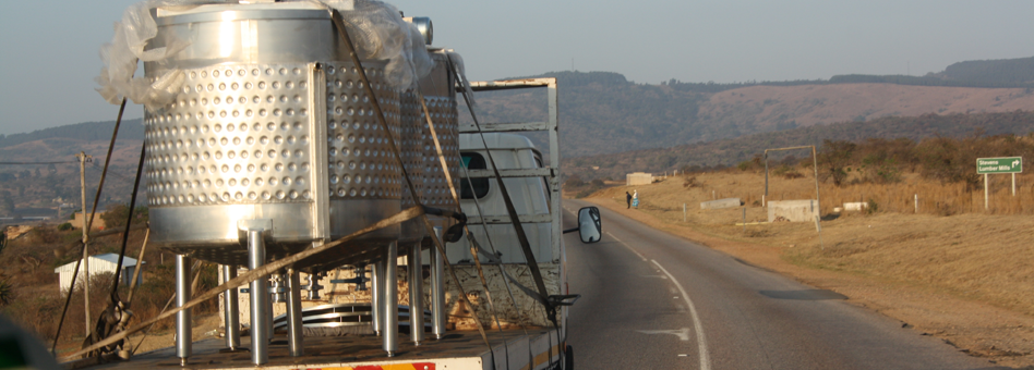
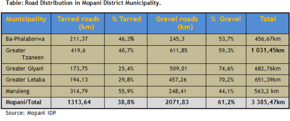
The Mopani District area has 3135.55 kilometers of roads. In the Greater Tzaneen Municipality the total length of tarred roads is 439.56 km and gravel roads is 593.44 km. The grand total kilometers of roads in the Greater Tzaneen area is 1033 km. For Greater Letaba Municipality, the distance of tarred roads is 150.5 km, whereas, the distance of gravel roads is 535.65 km; the total kilometers for the entire municipal area is 657.15 km. The kilometers of tarred roads in the Greater Giyani Municipality are 113 and the gravel roads distance is 605.8 km, totaling 718 for the entire municipality. The Ba-Phalaborwa Municipality has roads totaling 489.86, with 223.66 km of tarred roads as opposed to 266.2 km of gravel roads. Maruleng has 48.4km of tarred road and 188.7km of gravel roads and its total kilometers of roads is 237.54km. This reflection indicates that 975.06km of these roads are tarred and 2149.79 km are gravel. The state of roads in the district have an impact on the economic development of the area as it is clear that most roads, leading to where the majority of the district population is, are not tarred, and as such, hinder the proper transportation of people, goods and services to these areas.
National Roads in Mopani District Municipality
There are four major national roads that are found in Mopani district municipality. These are namely;
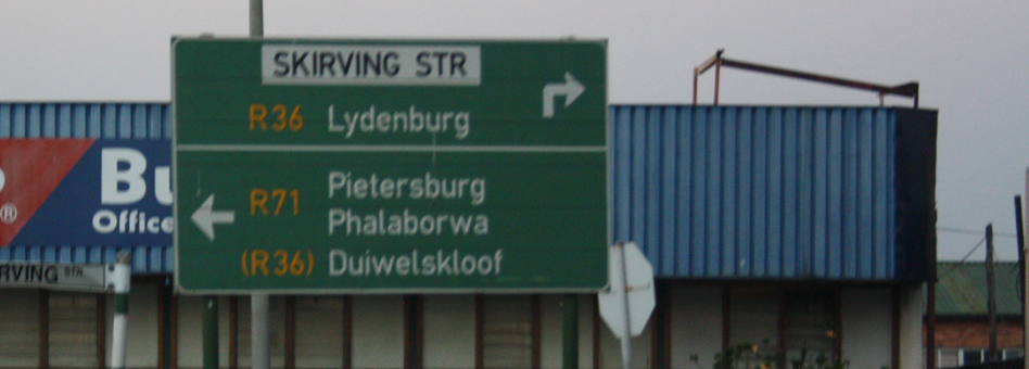
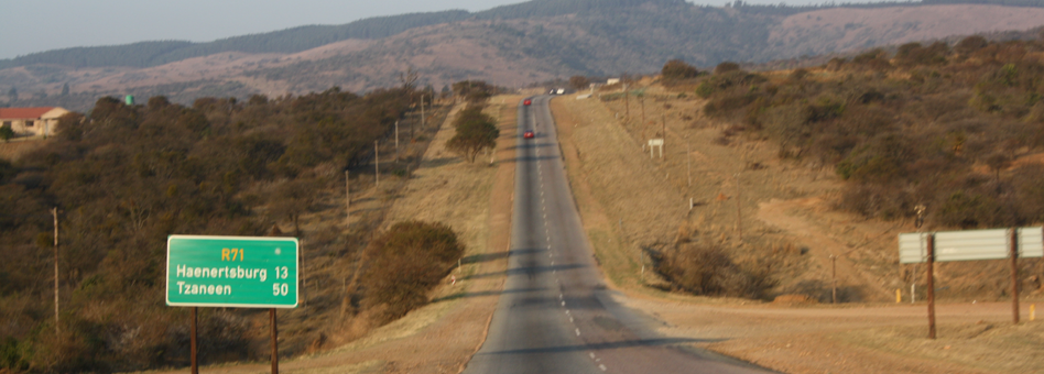
- R81: From Munnik to Giyani (Klein Letaba river).
- R36: From outside Morebeng to junction R71 & R36 (junction Makgobaskloof & Modjadjiskloof roads).
- R71: From Haenertzburg to Gravelotte (junction R40 & R71 roads), and
- R40: From Gravelotte to Klaserie (to Nelspruit to Barberton).
There are roads that lead to major tourist destinations in the District and Province. The need to strike a healthy balancing in terms of green freight as well as green infrastructure is therefore important.
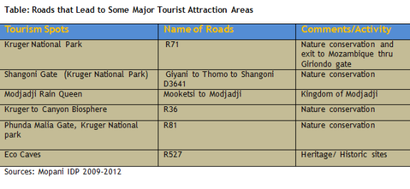
- Phalaborwa R71 - R36 - R81 to Polokwane
- Phalaborwa R40 to Mica to Bushbuckrigde
- Georges Valley road (Tzaneen - Polokwane) - R71
- R71 to Polokwane thru Makgobaskloof
- Dzumeri - Letsitele
Most of the gravel roads are not maintained regularly. In addition to that, some of the roads in the district do not have route names and numbers. They also do not have appropriate road signs (e.g. speed limits) as well as signs indicating distances between destinations. Another problematic issue on the district roads is that, in most areas, fencing along the routes has been removed. This has resulted in wild and domestic animals wandering on the roads with detrimental effect to motorists, and thus, negating our tourism attraction efforts as a region. Many road accidents in the district can be attributed to animals roaming on the roads. It is interesting to note new roads fencing projects in the district. The lowly serviced areas are mainly found in Greater Tzaneen Municipality and Greater Giyani Municipality. In Greater Tzaneen Municipality, the affected areas are the Boyne/Sedan areas and also Julesburg. Another area of concern is the Nwamitwa area. In Greater Giyani Municipality the affected areas are the Nkomo area and Matsotsosela areas. Compositely, the majority of rural streets are not well serviced. This provides an opportunity for the application of labour intensive methods (EPWP) in the servicing of rural streets. This would best apply if all municipalities and sector departments in the district quantify projects that do not need much capital injection in their implementation and use labour intensive (EPWP) methods. This would require a conscious effort and strategy to establish community partnerships that would ensure the beneficiaries physical involvement in government's rendering of public services.
Main Menu

Other Links
Copyright © 2012 Limpopo Province Freight Transport Data Bank | Developed and Powered by Safiri South Africa.