The District is made up of 5 local municipalities (LMs) - Elias Motsoaledi Local Municipality (formerly the Groblersdal Local Municipality), Fetakgomo Local Municipality, Greater Marble Hall Local Municipality, Greater Tubatse Local Municipality and Makhuduthamaga Local Municipality. Marble Hall Municipality is predictably found within the Marble Hall area, whilst the others are centred on major conurbations like Groblersdal (Elias Motsoaledi), Apel (Fetakgomo), Burgersfort (Tubatse) and Jane Furse (Makhuduthamaga). All these local municipalities constitute Greater Sekhukhune District Municipality (GSDM), which is a Category C municipality established in December 2000. The District was a cross-border municipality, straddling the Limpopo and Mpumalanga provinces until early 2006.
The entire district now falls in Limpopo Province found in the northern part of South Africa. The district which lies in the south-eastern part of the province, covers an area of approximately 13 264 square kilometers, most of which is rural with almost 605 villages, which are generally sparsely populated and dispersed throughout the District. It is estimated that only 5% of the Sekhukhune population live in urban areas. The area of Greater Sekhukhune District is endowed with some of the most lucrative mineral deposits in South Africa, including enormous reserves of platinum group metals. The area is mineral-rich but exceptionally dry, such that it experiences significant water shortages and is dependent on irrigation schemes for farming. The south-west part of the district contains one of the largest clusters of commercial agricultural production in the country. The critical water deficit affects households and is a major constraint to the growth of the agriculture and mining sectors - approximately 65 000ha of prime land cannot be farmed due to lack of water for irrigation.
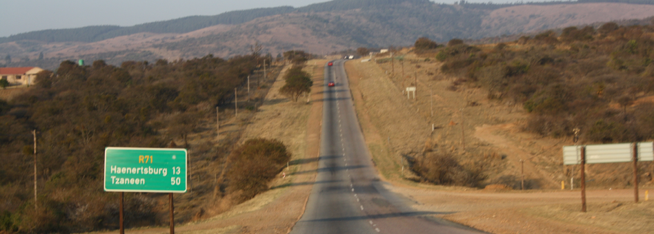
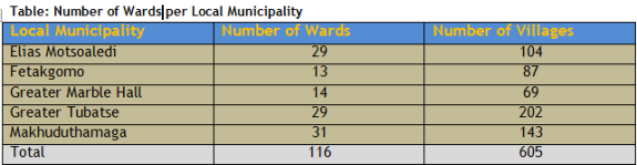
The N11 road network links the western portion of Sekhukhune with major highways and cities. Most smaller roads are in poor condition and there is an undeveloped road network in rural areas. GSDM is situated 200km north of Pretoria, 150km west of Nelspruit, and 120km south of Polokwane. The district consists of 116 wards which are broken down per local municipality as follows:
Modern-day Sekhukhune is found in Limpopo province, the northern-most part of South Africa. It covers an area of approximately 13 264 square meters, most of which is rural. It is estimated that only 5% of the Sekhukhune population live in urban areas. The main urban centres are Groblersdal, Marble Hall, Burgersfort, Jane Furse, Ohrigstad, Steelpoort and Driekop. Outside these major towns, one finds almost 605 villages, which are generally sparsely populated and dispersed throughout the District. The area's towns and villages are serviced by its major rivers - the Olifants River, Tubatse (Steelpoort) River and the Elands River, all of which supply a number of large dams. The Sekhukhune economy is driven largely by agriculture, mining and tourism.
Sekhukhune is an area with a long and proud history. It is also a place of majestic beauty with legal mountains, lush valleys and meandering rivers. Under its soil, lie vast deposits of precious metals - so vast that they today contain the largest reserves of platinum group metals in the world. Above its soil, sprout more than 2200 indigenous species of vascular plants, making it an area of exceptionally high biodiversity that is globally recognised. It is a land blessed by natural beauty, unusual resource endowments and a compelling history dating back to the 16th century.
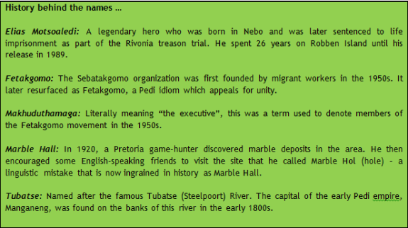
The people of Sekhukhune still remember the heritage bequeathed to them by their forefathers - by the legendary Chief Sekhukhune 1st who is still commemorated by South African leaders today, by the compassionate Pretoria Bishop, Michael Furse, who championed the cause of mineworkers in the early 1900s, by the hundreds of migrant workers who belonged to the celebrated Fetakgomo movement in the 1950s and by more recent heroes like Elias Motsoaledi. It is a legacy of resilience against all odds, and a commitment to uplifting the lives of the ordinary people of the region.
Modern-day Sekhukhune is found in Limpopo province, the northern-most part South Africa. The district which lies in the south-eastern part of the province, covers an area of approximately 13 264 square kilometers, most of which is rural with almost 605 villages, which are generally sparsely populated and dispersed throughout the District. It is estimated that only 5% of the Sekhukhune population live in urban areas.
The main urban centres are Groblersdal, Marble Hall, Burgersfort, Jane Furse, Ohrigstad, Steelpoort and Driekop. Outside these major towns, one finds almost 605 villages, which are generally sparsely populated and dispersed throughout the District. The area's towns and villages are serviced by its major rivers - the Olifants.
The area is governed by the Greater Sekhukhune District Municipality (GSDM), a Category C municipality established in December 2000. Until early 2006, the District was a cross-border municipality, straddling the Limpopo and Mpumalanga provinces. In 2005, following a Constitutional amendment prohibiting cross-border municipalities, the District was wholly incorporated into Limpopo Province - a move that has caused social tensions in the area.
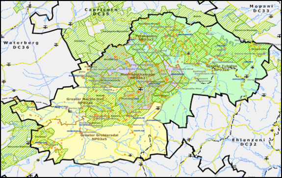
Figure: Map of Sekhukhune District municipality area
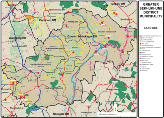
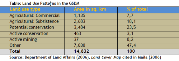
Land use within the Sekhukhune District is dominated by subsistence farming. This is especially true in the Fetakgomo, Makhuduthamaga, Marble Hall and Greater Tubatse municipal areas. The second significant land use is the potential conservation areas, especially within the Elias Motsoaledi and Marble Hall municipal areas. These potential conservation areas may eventually encompass roughly one third of Elias Motsoaledi and Marble Hall. The land use map below presents the picture.
The greater Sekhukhune District Municipality (GSDM) developed its first Spatial Development Framework (SDF) in 2004 which was adopted by Council. Some of the Local Municipalities within the District did not have SDFs then, and this clearly indicate that development was not properly managed in the absence of the SDF. The total population of the District is currently estimated at approximately 1024 748 (WSDP, 2005), with an expected population of 1068 662 (BMR) in 2009. The distribution of the population is however unevenly spread over the District as depicted in the below map. It reveals geographical disparities and a dispersed settlement pattern with few dominant concentrations points.
The account for this spatial structure and settlement pattern is the result of the spatial policies promoted by the former apartheid dispensation. As a result, the space economy of GSDM is characterized by a geographical spilt between former homeland areas, and areas which fell outside of the former homelands of Lebowa and kwaNdebele. Furthermore, the potential burgeoning of mining, agricultural, and tourism activities within the District presents spatial challenges of its own, amidst the inherited spatial challenges.
Land which formed part of the former homeland areas of KwaNdebele and Lebowa is generally characterized by low-density residential areas spreading over vast areas of land, and mainly occurs in two clusters - the Moutse area to the south-west and the central area around Jane Furse. Characteristically, residential areas located within the western extents of the District are more densely populated / developed than those in the north due their proximity to Gauteng. Conversely, land which fell outside of the former homelands are generally characterized by private / commercial farms, and medium density settlements clustered around semi-urban centres featuring retail and service-related activities.
More specifically, the GSDM features approximately 546 sparsely populated and dispersed rural settlements, with Groblersdal, Marble Hall, Burgersfort, Jane Furse, Ohrigstad, Steelpoort and Driekop constitution the main/first order urban centres. The spatial location of these first order centres generally coincide with the District's two dominant economic activity areas.
Essentially, apart from having been influenced by the spatial demarcation of the former homeland areas, the spatial occurrence of settlements has been influenced by:
�- The spatial location of major agricultural and mining activity areas;
- �The spatial location of major rivers traversing the District; and
- �The spatial location of major roads such as the R37 and R579.
Of utmost importance for the future spatial planning and development of the District, are the expected population concentration and growth areas. The reason being, that these areas not only serve to indicate where the greatest need for infrastructure spending could possibly be in the future, but also indicate where the municipality would receive the best value for money spent on infrastructure development and service provision. The existing Integrated Spatial Development Framework (ISDF) (2004) for the GSDM identifies the expected population concentration and growth areas / points of the district).
Growth points are individual settlements or settlement areas which feature strong economic, social and institutional activities. Table below indicates the expected population growth points for the GSDM.
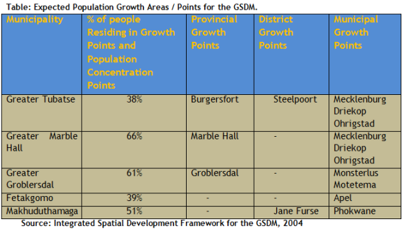
Of the total 14 growth points in Sekhukhune, 5 are situated within Greater Tubatse, followed by Greater Groblersdal and Marble Hall with 3 each, Makhuduthamaga with 2, and lastly Fetakgomo with only one growth point.
Population Concentration Areas / Points
Population concentration points are clusters of individual settlements with large numbers of people and high population densities. The GSDM features 12 population concentration points, with Elias Motsoaledi, Greater Marble Hall, and Greater Tubatse LMs featuring 3 concentration points respectively.
Local Service Points:
This includes settlements that have the potential to develop based on population growth, or servicing function potential. The Sekhukhune district has a total of 23 settlements falling under this category. The distribution of these settlements, per municipality, is summarized as follows:
- Fetakgomo (9);
- Greater Tubatse (7), Makhuduthamaga (4);
- Greater Groblersdal (2); and
- Marble Hall (1).
The challenge facing the District will be ensure the sustainable development of these population concentration and growth points, without neglecting the needs of the remaining extents of the Municipality.
Economic Activity Concentration
Economic Activity is predominantly concentrated in two areas, and include the local municipalities of Greater Marble Hall, Elias Motsoaledi (former Groblersdal) to the west, and Tubatse to the east. These areas also host the five main urban centres. Whilst the south-western economic activity area is primarily centred on intensive commercial agricultural, the north-eastern economic activity area is primarily centred on platinum mining activities associated with the Merensky Reef.
With less than ten percent of the total capacity of the Reef having been unlocked to date, the platinum economy is still within its infant stage. Tourism activities forming part of both of the economic activity areas are primarily related to nature tourism, game farming and hunting.
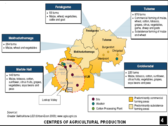
Figure - Centres of Agricultural Production
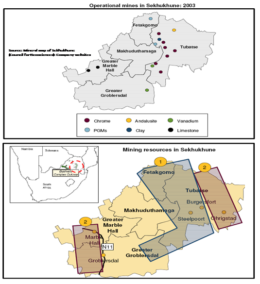
Figure: - Operational Mines & Mining Resources in Sekhukhune
Mining
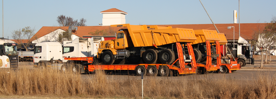
Modern mining has been practiced in Sekhukhune for well over a century, and typically involved (as is still the case today) the extraction of andalusite, asbestos, chromite and platinum deposits from the Merensky Reef, which forms part of the mineral rich Bushveld Complex. In fact, the District features the world's largest deposit of the platinum group metals (PGMs). What is striking about previous bouts of mining activity in the area is how changing commodity prices affected the opening, closing and, occasionally, re-opening of mines. When prices rose, new exploration and development took place in the Sekhukhune mining sector. Conversely, when prices fell, mines in the area closed. This is an important characteristic to take into consideration when providing infrastructure and housing to support expanding mining operations.
Currently, 17 operational mines are found within the District, with the majority of activity situated along the Dilokong Corridor (R37 and R555). The Dilokong corridor stretches across the Fetakgomo and Greater Tubatse LMs respectively. Some isolated activities are found within the Greater Marble Hall LM. Major mining companies operating in the GSDM (2006) include Anglo Platinum, Xstrata, BHP Billiton, Implants, ASA Metals and Marula Platinum. In spite of the involvement of major mining companies, mining in the District has not yet reached production limits. Consequently, a number of new developments are expected to take place. These include:
- Eleven new platinum and chrome mines over the next three years, possibly creating 17 000 direct jobs.
- A R2 billion smelter plant is being considered for construction in Tubatse, possibly creating 1200 jobs.
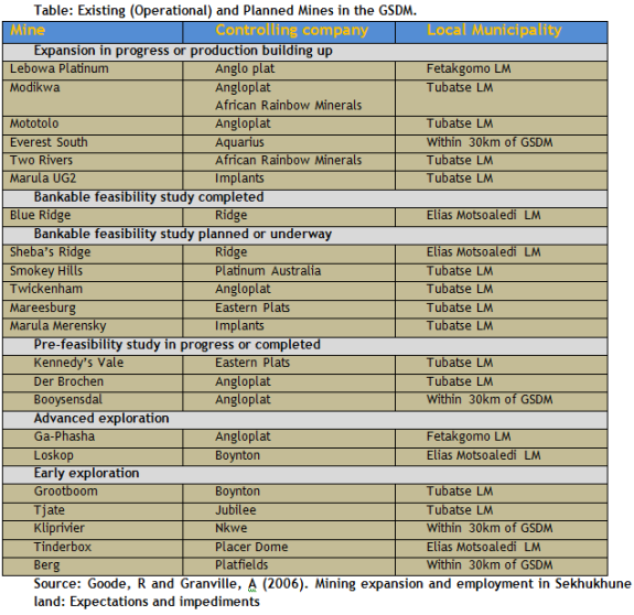
New mining activities within the Greater Marble Hall and Elias Motsoaledi LMs could potentially create land use conflicts between mining and agricultural activities. Furthermore, new mining activities may result in increasing pressure being placed on environmentally sensitive areas found within the north-eastern and south-eastern extents of the District. Table below sets out the main existing (operational), and planned platinum mines in the District.
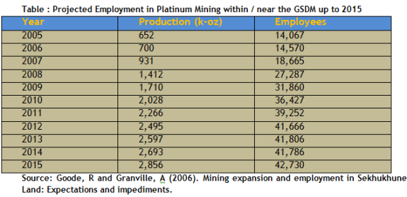
The projected number of employment opportunities in platinum mining within / near the GSDM up to 2015 is set out in Table below. Importantly, based on the below mentioned statistics, Burgersfort is set to become a city in the next 10-15 years.
Agriculture
Agriculture in the GSDM is a mixture of both commercial and subsistence farming. The south-western corner of the District (Greater marble Hall and Elias Motsoaledi LMs) specifically, contains one of the largest clusters of commercial agricultural production in South Africa. However, in spite of being an important contributor to employment within the District, agriculture remains a relatively marginal contributor (approximately 9, 7%) to the aggregate GGP of the District. Water scarcity, and the uncertainty created by land claims is unfortunately discouraging the expansion of commercial agricultural activities.
Essentially, commercial agriculture in the GSDM is concentrated in two main areas:
- The south-western part of the District (near Groblersdal and Marble Hall) (the Loskop Scheme); and
- The eastern section of the District (near Burgersfort and Ohrigstad) (the Ohrigstad Scheme).
The Loskop Scheme
The towns of Groblersdal and Marble Hall are found within the Loskop Valley. The commercial agricultural schemes in this valley are serviced by the Loskop Dam. In addition to the Loskop scheme, there are 5 smaller schemes within the Loskop agricultural area, namely:
- The Moosrivier scheme;
- The Hereford Scheme;
- The Olifants River Scheme;
- The Elands River Scheme; and
- The Selons River Scheme.
Collectively, these contribute significantly to commercial agriculture in the area.
The Ohrigstad scheme
The Ohrigstad Scheme is supplied with irrigation water from the Ohrigstad Dam along the Ohrigstad River. The total area currently being irrigated is estimated at roughly 4,500 hectares.
Alternatively described, the agricultural activities within the GSDM tend to be concentrated along the following routes:
- The entire length of the N11 throughout the District;
- The R573 from Marble Hall to the District boundary;
- The R25 between Dennilton and Groblersdal;
- The minor road linking the R573 and R25 between Groblersdal and Marble Hall;
- The R36 as far north as Branddraai; and
- The southern section of the R37 as far north as Burgersfort
Tourism
The District hosts the scenic Flag Boshielo Dam area, the adjoining Schuinsdraai Nature reserve, Potlake Nature Reserve and the Maleoskop resort and conservancy. Furthermore, the District has recently established the Kamoka Open Africa Route, which could be linked with the existing African Ivory and Cultural Heartland routes and the planned Great Limpopo Route.
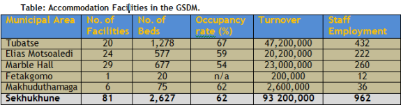
Currently, an estimated 84 accommodation facilities, offering 2,627 beds are found throughout the GSDM. The tourism sector also employs approximately 962 persons. The table below sets out the accommodation facilities currently available in the District.
Yet, in spite of existing tourism attractions and facilities, and although tourism has been identified as one of the major growth sectors in the GSDM, the District lacks a major product to draw a significant volume of holiday tourists to the area. A major draw card could however firmly place Sekhukhune on established tourist routes to the Blyde River Canyon and Kruger Park.
The following are the development objectives to be achieved as part of the Spatial Development Framework for the Greater Sekhukhune District Municipality:
- To actively protect, enhance and manage the natural environmental resources in the municipality in order to ensure a sustainable equilibrium between the mining, tourism and agricultural industries in the area.
- To optimally capitalize on the strategic location of the District by way of strengthening of internal and external linkages within provincial and regional context.
- To utilized the natural environmental and cultural historic features in the District as anchors from which to promote ecotourism and conservation.
- To maximally utilise the mining potential in the district by way of the development of the Dilokong Corridor.
- To promote commercial farming and food production along the Olifants River and Steelpoort River drainage systems in the District.
- To facilitate small scale and subsistence farming activities throughout the remainder part of the municipal area.
- To promote industrial/commercial development in the District with specific emphasis on Agri-processing in the agricultural belt (Groblersdal), and mining/ore-processing in the mining belt (Tubatse).
- To create a strong east-west movement/development corridor in the District functionally linking the tourism precincts, mining belt and agricultural belt to one another, and to the markets of Gauteng Province along the Moloto Corridor.
- To supplement the District east-west corridor by way of three functional north-south corridors:
- N11: Agriculture, Commercial
- R583: Institutional, Residential
- R33: Mining
- To ensure equitable access to social infrastructure and to promote Local Economic Development by way of an evenly distributed range of Multi-Purpose Community Centres to be established throughout the District.
- To consolidate the urban structure of the district around the highest order centres by way of infill development and densification in Strategic Development Areas.
- To establish a functional hierarchy of towns and settlements in the District based on the regional function and spatial distribution of these centres.
Strategic Development Areas
The currently dispersed settlement structure of the District has not only resulted in the costly duplication of essential community services and infrastructure, but has left some communities without access to these. Hence, proper planning in respect of the placement of the provision of resources is necessary to bring about an even, equitable, and cost-effective distribution of essential community services and infrastructure throughout the entire municipal area.
To achieve this, the SDF proposes the establishment of a functional hierarchy of towns and settlements, as well as the establishment of a hierarchy of service centres throughout the entire municipal area by way of Multi-Purpose Community Centre (MPCC) development. Such an approach to the delivery of community services is aligned with both the National Integrated Sustainable Rural Development Strategy (ISRDS), and the DM's LED strategy which strives to promote nodal development. Establishing a hierarchy of services centres in the form of MPCCs holds the following advantages:
- Contributes towards urban-rural restructuring and environmental protection by means of promoting nodal development. Nodal development is conducive to targeted infrastructure spending, local economic development and corridor development;
- Promotes comprehensive regional development;
- Helps to speed-up infrastructure development and service delivery;
- Reduces the levels of inequality in living standards and access to basic services between rural and urban areas - ensures that all communities have access to at least the minimum levels of services as enshrined in the constitution;
- Basic services are provided by government in a financially sustainable manner;
- Provides government with a platform from which to develop energy centres, tele-centres and information technology infrastructure within rural areas;
- Provides a platform for entrepreneurship and small business development(LED);
- Provides guidance for the development and provision of engineering services;
- Indicates where to provide tarred road infrastructure and multi-modal transport facilities; and
- Helps to determine public transport service points and routes.
In terms of establishing a hierarchy of towns and settlements for the District, the SDF proposes the following:
Primary Nodes
- Burgersfort as the primary mining and industrial node of the District.
- Jane Furse as the institutional capital node of the district.
- Groblersdal as the primary business and agricultural node of the district.
Secondary Nodes
- Steelpoort
- Marble Hall
- Ohrigstad
These nodes have primarily been identified based on their regional accessibility, their central locations within the two primary economic activity areas, their status as growth points, and for coinciding with existing or proposed new bulk water distribution infrastructure.
As mentioned, in order to bring about an even, equitable, and cost-effective distribution of essential community services and infrastructure throughout the entire municipal area, the SDF also proposes the establishment of a hierarchy of service centres, based on a 10km services radius.
Taking into consideration the overall development strategy for the District, which seeks to consolidate the fragmented and dispersed settlement structure, the SDF proposes a phased development approach. This implies that the Municipality should first develop all the 1st Order Priority MPCCs, before moving onto the second and third order ones. The development order, total number, and spatial location of the proposed services centres, were determined by taking into consideration the growth points, the population concentration points, the primary and secondary routes, as well as existing and proposed bulk infrastructure.
Importantly, to ensure that the Municipality lives up to its Constitutional obligation whilst striving to consolidate the dispersed settlement structure, the SDF proposes that the proposed MPCCs should form the focal point of infrastructure provision within the rural extents of the DM
.Existing Land Use and Related Potential
Land use is a complex issue, and is partially the result of the physical planning policies of the former apartheid government, which split the District between former homeland areas, private farms and small towns. Today, apart from issues pertaining to land ownership patterns, mining, agricultural and tourism activities bring distinctive spatial challenges of their own to the District.
Presently, land use within the GSDM is dominated by commercial and subsistence farming. This is especially true in the Fetakgomo, Makhuduthamaga, Marble Hall and Greater Tubatse Local municipal areas. The second most significant land use is the potential conservation areas, especially within the Elias Motsaledi and Marble Hall municipal areas. These potential conservation areas may eventually encompass roughly one third of Elias Motsoaledi and Marble Hall. The different land use patterns in the Sekhukhune District are captured in the Table below.
Disconcertingly, land is becoming an increasingly scarce commodity within the District. This is equally true of rural, semi-rural / semi-urban areas. This is a particularly significant situation, given the growing importance of agriculture, mining and tourism (all potentially conflicting land uses) to the District's economy. Furthermore, the District's developing economic nodes appear to be attracting an increasing number of people, thereby creating higher population concentrations in certain parts of the District. This is especially true of the June Furse-Phokwane development node in Makhuduthamaga, the Bothashoek-Praktiseer area (Tubatse) and the Atok area (Fetakgomo).
Spatial Restructuring and Service Provision
The Sekhukhune District is spread over former homeland areas, commercial farms, towns and semi-urban centres. According to the Limpopo Spatial Rationale Study (2002), Sekhukhune has roughly 605 settlements which are fairly dispersed. There are a number of ways of classifying settlement patterns. A particularly useful delineation, however, may be found in the Integrated Spatial Development Framework, which identifies four dominant Patterns in the Sekhukhune District.
This includes first order settlements, which encompasses all provincial, district and local growth points. In addition, second order settlements are those areas with a sizeable population but that are found outside the primary first order settlements. Third order settlements are local services points with some potential for future growth. Finally, fourth order settlements are scattered small settlements with very little potential for growth.
The first order settlements are of particular interest to this IDP. In 1999, the Limpopo Spatial Rationale identified the following:
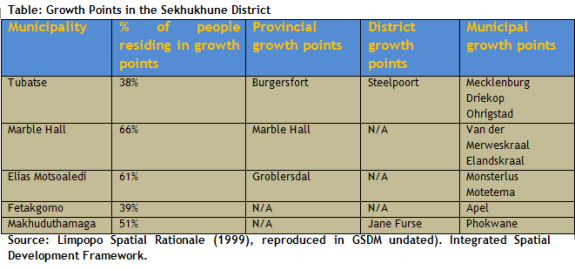
This is graphically depicted in the map below.
Figure - Growth points in the Sekhukhune District
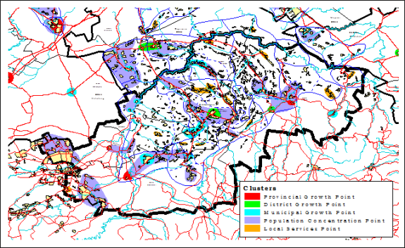
Source: Procurement Dynamics (undated). Synthesis report of the research.
Stimulating the continued development of these growth points, whilst simultaneously ensuring balanced sustainable development throughout the District, is likely to be a key challenge for the municipality in the next few years.
Land Use Management
An even more complex issue within the District, however, is that of land use management. The land issue is a potentially difficult one in Sekhukhune, with the District being governed by a dual system. Under the traditional system, land allocation (and, therefore, land use) is the prerogative of tribal council - and this system dominates in much of the District (especially in the townships and rural villages).
Other parts of the district, however, are governed by modern post-apartheid land legislation such as the Development Facilitation Act, the Municipal Systems Act and the Communal Land Rights Act. This modern system holds sway in the District's formal towns and, to some extent, the adjacent townships.
The traditional system is rendered more complex by the fact that each of the approximately 70 traditional authorities in the area has its own unique land use management system. In general, however, each traditional authority allocates land to a subject for either residential use or subsistence farming. In addition, subjects would also have unlimited access to communal grazing land, which often cuts across traditional authority boundaries. The communal grazing system, however, is becoming increasingly difficult to maintain, given the growing demand for land (for a range of purposes). Furthermore, the traditional land use management system is unwritten and therefore often subject to interpretation.
In recent years, the boundaries between different traditional authority areas have become increasingly blurred. This has led, in part, to the lodging of competing land claims in many parts of the District�. It has also led to the growth of informal settlement activities within some traditional authority areas. This is especially prevalent around district growth points like Burgersfort, Atok and Jane Furse and is undoubtedly a reflection of economic migration towards potential centres of economic activity.
Recent trends
According to background research done for the District's 2025 Development Strategy, Sekhukhune's developing economic nodes appear to be attracting an increasing number of people, thereby creating higher population concentrations in certain parts of the District. This is especially true of the Jane Furse-Phokwane Development node in Makhuduthamaga, as well as the Bothashoek-Praktiseer area (Tubatse) and the Atok area (Fetakgomo).
In the hinterlands, by contrast, land uses such as conservation appear to be developing more rapidly. This is particularly the case within the local municipal areas of Marble Hall, Elias Motsoaledi and Tubatse.
Finally, the central municipal areas of Makhuduthamaga and Fetakgomo are characterized by mixed land uses of subsistence farming and residential uses.
Roads infrastructure established has connected the district with different economically potential areas at all fronts (South, East, West, and North). The remaining challenge that will be addressed in the not distant future is the construction of access roads leading to and within the villages of Sekhukhune District.
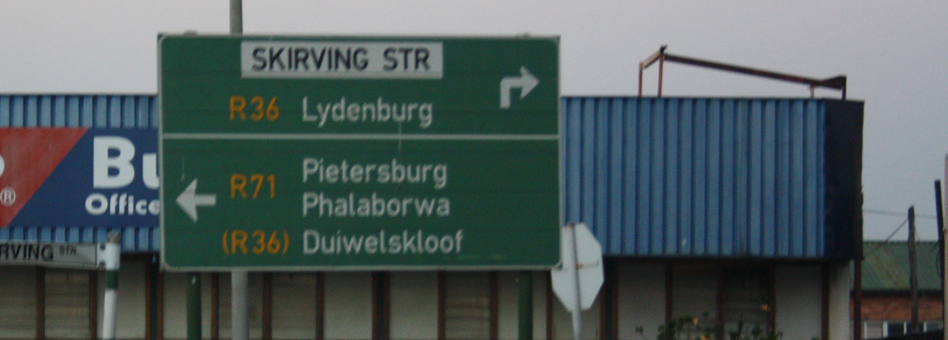
As mentioned, the District's transport network is largely limited to a number of arterials which provide regional accessibility, rather than local accessibility. From east to west, these include the N11, R25, R33, R579, R555, R37 and R36. Hence, regional accessibility is predominantly facilitated via three roads traversing the District in a northwest - southeast alignment (N11, R579 and R37), one road traversing the District in a northeast - southwest alignment (R555), and the R36. Together these roads constitute the main freight and logistics corridors connecting the District's economic activity areas to prominent provincial nodes and economic activity areas falling outside of the District - e.g. Mookgopong, Mokopane, Polokwane, Lydenburg and Middleburg. The presence of the Klein Drakensberg and Strydpoortberge hinders connectivity to the north-east.
More specifically, the N11 Freeway connects the town of Marble Hall and Groblersdal with Mookgopong and the N2 Freeway towards the north-west, which leads to Mokopane and Polokwane. To the south, the N11 connects Marble Hall and Groblersdal with Middleburg, which is situated along the N4 Maputo Corridor. The R579 traverses the central extents of the District, and serves to connect Jane Furse and Monsterlus with Lebowakgomo towards the north, and Sehlakwane and Stoffberg towards the south.
The R37 traverses the northern extents of the District, and serves to connect Burgersfort with Lebowakgomo towards the north-west and Lydenburg towards the south-east The R555 traverses the eastern extents of the district, and serves to connect Steelpoort and Burgersfort with Stoffberg towards the south-east. These two roads from the Dilokong Platinum Corridor, once past Burgersfort, R555 become the R36 which serves to connect the Burgersfort / Steelpoort area with Ohrigstad, and down to Lydenburg.
Although the majority of the major urban centres and smaller towns are located along these roads, vast number of settlements within the western, central, and eastern extents of the District are only accessible via secondary gravel roads. There is however relatively little economic activity within these areas to justify the construction of additional tar roads.
The general condition of roads within the GSDM is poor. Severe damage such as potholes, cracks, and rutting can be observed along most roads. Road damage is particularly prevalent along the following sections of road:
- The R33 between Groblersdal and Stoffberg;
- The R555 between Stoffberg and Roossenekal;
- The R579 between Nebo and Stoffberg; and
- The R25 between Dennilton and Groblersdal.
To ensure alignment with the Limpopo Provincial Growth and Development Strategy (LPGDS), the District has prioritized its roads forming part of the Dilokong and Phalaborwa Corridors, and includes the following stretches of road:
The Dilokong Corridor
- Polokwane to Burgersfort (P33/1 and P33/2) (R37), via Mafefe.
- Flag Boshielo Dam through Lebowakgomo and Mafefe, linking the District with the Phalaborwa and Kruger National Park areas.
- Chueniespoort via Boyne to Mankweng.
The Phalaborwa Corridor
- Ohrigstad via the Strijdom Tunnel (P116/1).
- Burgersfort to Oaks (P181/1).
Apart from its road network, the GSDM is served by three railway lines which were originally developed to support the mining activity within the District. The Three railway lines are:
- The railway line entering the GSDM from the south, next to Stoffberg, from where it continues northwards for approximately 30km, eventually ending at an abandoned mine near the Mapochs Mine.
- The railway line entering the GSDM from the west, near Nutfield, from where it continues eastwards to Marble Hall.
- The railway line entering the GSDM from the east, passing near Ohrigstad and Burgersfort, and ending near Steelpoort (near the Tubatse mine).
Unfortunately, these railway lines have not yet been extended or re-routed to serve later / new mining operations (such as those along the Merensky Reef and Chrome layers). Consequently, shortcomings in the railway network are resulting in extreme pressure being place on the road network. Favourably, a new commuter rail link between Pretoria and the south-west of the GSDM (along the Moloto Road) is being considered. This rail link will improve accessibility to Gauteng, which represent an employment area for many residing within the south-western extents of the District.
In addition to the road and railway network of the District, two registered airfields are also found within the District. The airfields are located in Marble Hall and Groblersdal respectively, and primarily support crop spraying activities.
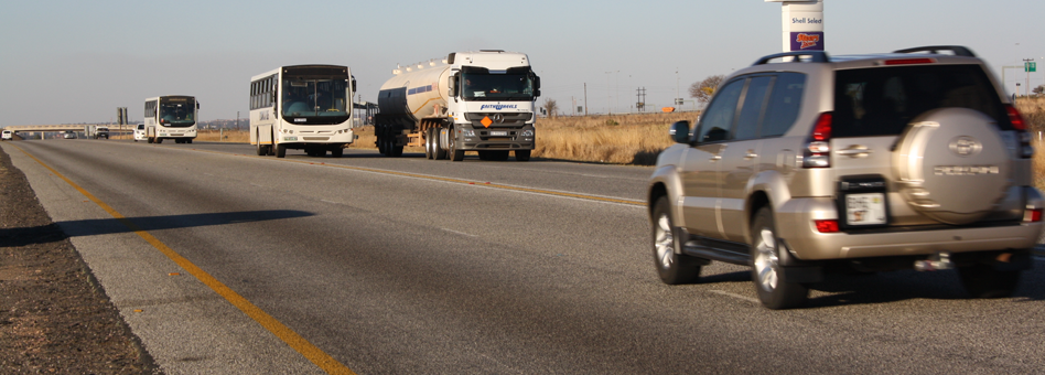
Mode of Transport
The main modes of transport in GSDM were buses, taxis and trucks. There were 45.02% of the people travel on foot to go to work and some to schools. 1.45% of the people in the District prefer to travel by taxis while 1.39% of people prefer to travel by bus. All the five local municipalities in the district depended on taxis and buses which were subsidized and some were not subsidised.
Development of Road and Transport Network in GSDM
The development of the road and transport network in Sekhukhune is of vital importance given the planned economic trajectory of the District, as well as the potential offered by the Dilokong Corridor. In general, the district is well connected to its surrounding areas to the East, West and South. However, geographic factors have hindered connectivity impeded road construction there. There is, in fact a stretch of approximately 150km between Lebowakgomo and the R36 through the JG Strijdom tunnel without tarred road access northwards.
Within the District itself, there is a general lack of roads - and of tarred roads in particular - connecting the inner section of Sekhukhune, which consists largely of scattered villages with minimum economic activity at present. The District has decided however, not to encourage continued scattered development at present - and future transport routes will therefore be concentrated along the major nodes of economic activity. It is hoped that this will encourage workers from the rural areas to urban areas - a philosophy in line with the NSDP principles.
In contrast to the inner section of the District, the semi-urban areas of Sekhukhune are relatively well-serviced by the Provincial and National routes running through it. These routes, as will be seen later in this section, are supporting the area's main economic activities reasonably well at present. What remains to be seen, however, is whether the planned platinum mining expansion in the area will be adequately served by current infrastructure in the District.
The Road Network in Sekhukhune
According to the powers and functions, the District Municipality is responsible for the development of roads only in Fetakgomo Local Municipality. The Sekhukhune District has one major national road within it (the N11), as well as several provincial arterial routes including the R25, R33, R36, R37, R555, R573 AND R579. There are also a limited number of tarred minor roads, such as those leading into Jane Furse. The remainders of the roads in Sekhukhune, however, are largely gravel roads that serve to connect the rural areas within the District.
The total length of the Sekhukhune Road network under the District's control is at 1,491km. the following table summarizes the situation as per municipality:
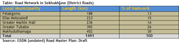
The draft Road Master Plan estimates the current backlog as follows as follows:
- Upgrading of 71.89 kilometers from unpaved to paved for Fetakgomo municipal roads.
- Upgrading of 187 kilometers of District roads from unpaved to paved.
- Re-gravelling of 1.122 kilometers of District Roads.
The Railway Network
The Sekhukhune district has three railway lines, originally developed to serve mining activity in the area. These are:
- The railway line entering Sekhukhune in the south next to Stoffberg, which continues northwards for 30kms (it leads to an abandoned mine near the Mapochs Mine).
- The line entering Sekhukhune in the west near Nutfield, which continues eastwards to Marble Hall.
- The line entering Sekhukhune in the east, passes near Ohrigstad and Burgersfort (past abandoned mine) and ends near Steelpoort (near the Tubatse Mine).
It became obvious that these lines, originally developed to serve past mining and agricultural activities in Sekhukhune, have not been re-routed to serve new (or future) mines in the area.
If this continues, the results will be that mining expansion in Sekhukhune will place additional burden on the road network in the area. Beyond commercial usage, a commuter rail link between Pretoria and south-west part if Sekhukhune (along the Moloto Road) will clearly be useful, given the high levels of male migrancy.
Development Corridors in Sekhukhune
The PGDS identified four development corridors, which will drive future economic development in the province. Of these, the Dilokong and Phalaborwa Corridors travel through the Sekhukhune District and are of immediate economic relevance for the area.
The Dilokong Corridor includes three important roads that fall within the Sekhukhune area. These are:
- Polokwane to Burgersfort (P33/1 and P33/2 via Mafefe
- Flag Boshielo Dam through Lebowakgomo and Mafefe, linking the Sekhukhune District with the Phalaborwa and Kruger National Park.
- Chuenespoort via Boyne to Mankweng
- The Phalaborwa Corridor connects Hazyview (Mpumalanga) with Phalaborwa and Tzaneen through a number of small towns on the western side of the Kruger National Park. It includes two roads sections that fall within the Sekhukhune area.
- Route section P17/3-5, D726, P112/1-3, P43/2, D1308 and P54/1.
- Road section P146/1 from Klaserie to Blyde River, P116/1 from Hoedspruit to Ohrigstad via the Strijdom Tunnel and P181/1 from the Oaks to Burgersfort.
The District will look carefully into the prioritization of these roads, given their economic significance in both Sekhukhune and the province more generally.
Implications for Future Economic Growth in Sekhukhune
The road network in Sekhukhune is clearly in need of some maintenance in the future. This will became especially important given the planned economic growth of the District.
Developmental Challenges
- Grading of internal access roads (streets)
- Construction of bridges
- The tarring of roads
- Provincial arterial roads are deteriorating rapidly because of a lack of maintenance
- Local access roads are gravel, below standard and used mainly by buses and taxis
- Local gravel roads also need stormwater management
Transportation in GSDM
For goods and services to be transported throughout the District, organized transport system is required. The main transport systems are the following: busses, taxis, and trucks. There are two types of bus companies which are private and public. Private are those that are owned by individuals not related to government and public are those that are owned by an organ of state or government itself.
Air Transport
There are no commercial airports or air transportation in the District. at present, there are only two registered airfields in the town of Groblersdal and Marble Hall. They are used as emergency airfields. They are utilized mainly by the business and tourism sectors, as well as local farmers wishing to spray their cultivated fields. There is also an air strip in Elanskraal in the Greater Marble Hall Municipality, which is not maintained.
Public Transport
According to the District's Integrated Transport Plan, the most common forms of public passenger transport are the buses and taxes. The taxi industry determine its routes largely by looking at factors like the location of towns and villages, dominant economic activities in the area and employed status within the district.
Transport routes in Sekhukhune are often limited by deteriorating roads conditions as well as local storm water problems caused by rainy season. The following are the findings of the review of the Greater Sekhukhune District Current Public Transport Record (CPTR) and Integrated Transport Plan (ITP) in 2007. The report covered an overview of what is involved in public transport in the Greater Sekhukhune District Municipality with regard to facilities, the capacity utilization of ranks and routes, the waiting times of passengers and vehicles, the operational vehicle and the number of trips made per operational vehicle. The facility surveys were conducted at taxi ranks, bus terminals and train stations.
The facility survey conducted indicate that the Greater Sekhukhune District Municipality. No commuter rail service is currently provided for passengers. There are three bus terminals in Greater Sekhukhune District Municipality has a total of 82 taxi facilities of which more than 75 per cent are informal. There are three bus terminals in the Greater Sekhukhune District Municipality. No commuter rail service is currently provided for passengers.
190 (approximately 50% outwards-bound) taxi routes in the GSDM: 15% are in the Elias Motsoaledi LM, 3% in Fetakgomo LM, 17% in Greater Marble Hall LM, 43% in the Greater Tubatse LM and 22% in Makhuduthamaga LM.
Of the subsidized bus routes in the GSDM, 57% are in the Elias Motsoaledi LM and 43% in the Greater Marble Hall Municipality. The main findings obtained from the analysis of the route utilization are that there is a vast oversupply of taxis on most routes in the GSDM.
The route utilization survey noted 1462 taxis in the GSDM area. Furthermore 1372 taxis were noted in the Elias Motsoaledi LM, 287 in Fetakgomo LM, 530 in Greater Tubatse LM and 1083 in Makhuduthamaga LM.
There are 28 buses in operation on the subsidized routes in the GSDM area. There are metered-taxi activities in the Greater Tubatse LM. Light delivery vehicles (LDVs) are utilized for learners' trips as well as the areas where the quality of the road is not good.
Developmental Challenges
- Light delivery vehicles used for the transportation of learners
- Deterioration of road infrastructure
- Lack of facilities for heavy vehicles
- Inadequate signage
- Lack of alternative routes for trucks.
Transport, Logistics and Communications
The transport, logistics and communications sector is becoming significantly more important in Sekhukhune, especially with gradual increase in activities of other economic sectors. The anticipated expansion in mining, for instance, offers tremendous opportunity for passenger transport and material. Similarly, public sector infrastructural development also demands the movement of huge amounts of material and people.
Development corridors in Sekhukhune
A number of development corridors have the potential to promote economic growth within the Sekhukhune District (GSDM, undated, b). These are described below.
The Dilokong CorridorThe Dilokong (Platinum) Primary Corridor is an extremely important corridor to both Sekhukhune and the province. It correlates largely with the R37 road, which runs from Polokwane through Lebowakgomo to Burgersfort.
The Dilokong corridor is characterized by booming mining activities alongside its trajectory. Projected mining expansion in the area is likely to boost the importance of this initiative as well. Tubatse benefits the most from developments in this corridor, with lesser benefits accruing to Fetakgomo as well.
The Dilokong Corridor also encompasses a number of growth points including Atok (within Fetakgomo), Mecklenburg and Burgersfort. The Burgersfort cluster includes a provincial growth point (Burgersfort), District growth point (Steelpoort) and municipal growth point (Driekop). The remaining settlements which forms part of the Burgersfort cluster, have been classified as population concentration points. These settlements are also important in the development of the area mainly because they have residential development potential for the mines (GSDM, undated, b).
The N11 corridorThe primary N11 corridor runs from Botswana through Potgietersrus down to Groblersdal and onwards to Middleburg on the western side of the District. It serves as a major transport route in the western part of the District, particularly for transporting agricultural produce. The road conditions along this corridor are fairly poor, however.
Marble Hall and Groblersdal fall within the N11 corridor. These towns have also been classified as provincial growth points because of their important service function to the surrounding communities, as well as their linkages to the surrounding communities, as well as their linkages to the agricultural sector (GSDM, undated, b).
Jane Furse CorridorThe mainly residential development on the road between Lebowakgomo via Ga-Masemola and Ga-Phahla to Jane Furse and Glen Cowie/Phokwane can be classified as a secondary development corridor within Sekhukhune. This corridor does not form part of SDI route, but is a corridor in terms of the nature and extent of the large population concentration in the area.
This secondary corridor also has some economic potential, largely because of the presence of Jane Furse.
Burgersfort/Stoffberg CorridorThis secondary corridor can play a significant role in the development of mining. It extends from Burgersfort via Steelpoort to Stoffberg. A number of mining activities are taking place at the moment along this corridor. Proper infrastructure will be required to facilitate mining expansion, however. Proper development of this corridor will stimulate economic development of the surrounding areas. It will mostly cater for the transportation of goods and services.
Other CorridorsThe following tertiary corridors where identified within the Sekhukhune District Municipality:
- From Burgersfort to Penge
- From Marble Hall to Siyabuswa
- From Groblersdal to Stoffberg
- From Marble Hall along the Olifants to Atok
- From Jane Furse to Nchabeleng
These corridors have various clusters, which are primarily classified as population concentration points, including municipal growth points. They also connect various villages with different growth points. They are strategically distributed and links well with the primary and secondary corridor identified above. Some of the identified tertiary corridors need upgrading in order to stimulate economic growth in these clustered villages and municipal growth points.
Main Menu

Other Links
Copyright © 2012 Limpopo Province Freight Transport Data Bank | Developed and Powered by Safiri South Africa.